PEEKABOO LOOP

JANUARY 2012

VIEW FROM ALONG THE TRAIL

WALL OF WINDOWS

THORS HAMMER

WALL OF WINDOWS

WALL OF WINDOWS

HOODOO ALONG THE TRAIL

HOODOOS
THE TRAIL PASSING THROUGH A TUNNEL

PEEK-A-BOO LOOP TRAIL

VIEW FROM ALONG THE TRAIL
The Peekaboo Loop trail is a three-mile round-trip loop located at the bottom of Bryce Canyon between Sunset Point and Bryce Point that can be accessed from several different trailheads. I chose to access it from Sunset Point and combine it with the Navajo Loop for an approximately five-mile round-trip hike. As Bryce Canyon can get extremely congested during the spring, summer and fall, I chose to visit in the winter over New Year's. If you visit in the winter, you will want to watch the weather. Because Bryce Canyon is located at nearly 8,000' in elevation, it has the potential to receive a lot of snow. Thankfully, there was not too much snow on the trail when I visited in in 2012.   

This may be my favorite hike in Bryce Canyon, as there is incredible scenery along the entire route. Also, because Navajo and Peekaboo are both loop hikes, you get fresh views along almost the entire route. I remember passing several hikers on the Navajo Loop, but having the Peekaboo Loop almost entirely to myself. This was really nice, as it can be a real challenge escaping the crowds at Bryce Canyon. I guess the secret is to visit in the winter, and to hike at least a mile in from the main trailheads.    

WILLIS CREEK

NOVEMBER 2008, NOVEMBER 2012 & NOVEMBER 2018


WILLIS CREEK NARROWS

WILLIS CREEK NARROWS

WILLIS CREEK NARROWS


WILLIS CREEK NARROWS


WILLIS CREEK

WILLIS CREEK

WILLIS CREEK NARROWS


Willis Creek is a beautiful slot canyon located near Kodachrome Basin State Park that does not require much hiking to reach. From Cannonville, you will travel south on Kodachrome Road for about two-and-a-half miles, and take a right onto Skutumpah Road, which you will follow for about six miles to the Willis Creek Trailhead. Skutumpah Road is a fairly-well maintained dirt road which I was able to travel both times I visited in a Corolla without much trouble. To reach the Willis Creek Narrows from the parking area, you will just need to cross the road and follow the stream.  

The stream will quickly drop down into a slot canyon. Willis Creek runs right down the middle of the slot canyon, so be prepared to get your shoes wet. As both times I visited were in November, the water was not very deep. When I visited in 2008, I remember being able to keep my shoes fairly dry by walking on the frozen parts of the creek, before it melted, later in the day. Willis Creek goes for two miles before it runs into Sheep Creek, however the most interesting parts are located in the first mile or so. Willis Creek stays pretty narrow and interesting for the first mile, making it a very low-effort, high-reward slot canyon.

FAIRYLAND LOOP

NOVEMBER 2017


FAIRYLAND POINT

VIEW ALONG THE RIM TRAIL

TOWER BRIDGE

FAIRYLAND POINT

FAIRYLAND POINT

TOWER BRIDGE FROM THE MAIN TRAIL

VIEW ALONG THE TRAIL

FAIRYLAND CANYON

FAIRYLAND POINT

VIEW ALONG THE RIM TRAIL

ARCH LOCATED JUST OFF THE MAIN TRAIL

Fairyland Loop is a nice eight-mile round-trip hike through Bryce Canyon with fewer crowds than the more popular trails further down the road at Sunrise and Sunset Point. The road to Fairyland Point, is actually located before the fee station to the Park, which means you don't have to pay the $30 entrance fee to hike it. While the entire hike is nice, my favorite part is probably Fairyland Point, located at the very beginning of the hike, which provides a great view of some very photogenic hoodoos. 

From the trailhead, it is a four-mile walk past some nice hoodoos and at least one arch before arriving at the turn-off to Tower Bridge. The Tower Bridge detour is definitely worth your time, and you will actually get some nice views of it from the main trail before reaching the turn-off. From Tower Bridge, it is one-and-a-half miles back to the canyon rim, near Sunrise Point. This one-and-a-half mile section was extremely congested when I visited in November of 2017. The hike from the rim to Tower Bridge appears to be very popular. When I was hiking it, it appeared as though some large tour buses had just unloaded a hundred or more tourists at the trailhead to Tower Bridge. I had to keep stopping over and over to avoid getting in the all the pictures everyone along the trail waere taking of each other. 

Once you reach the rim, it is two-and-a-half miles back to Fairyland Point. This section was actually quite enjoyable, as there were very few people along this stretch, and you have some nice views of the canyon most of the way. All-in all I really enjoyed this hike. Because I had gotten to the trailhead first thing in the morning, I didn't see anyone on my four mile walk from Fairyland Point to Tower Bridge. As mentioned above, it was then a mile-and-a-half of extremely congested trail before arriving back at the rim for a peaceful, secluded stroll back to Fairyland Point.  

ROUND VALLEY DRAW

NOVEMBER 2008 & NOVEMBER 2017

ENTRANCE TO ROUND VALLEY DRAW

ROUND VALLEY DRAW NARROWS

ROUND VALLEY DRAW

ANOTHER VIEW OF THE ENTRANCE

ROUND VALLEY DRAW

NARROWS NEAR THE ENTRANCE


PLEASANT NARROWS

LOOKING INTO A NARROWS SECTION

Round Valley Draw is a great slot canyon hike located near Kodachrome Basin State Park, just a little past Grosvenor Arch. To reach it you will travel south down Cottonwood Road, and take a right onto Road 422. From the turn-off it is approximately 1.5 miles to the trailhead. There is one dry stream bed crossing near the beginning of the road that is a bit rough, and on my first visit in November of 2008 I parked in front of it and hiked the extra mile or so to the trailhead to be safe. However, on my second trip in November of 2017, it didn't look as rough, and I was able to drive over it and make it nearly all the way to the trailhead.  

Make sure you bring some good directions. The first time I hiked this, I had no trouble at all finding the right routes to the narrows, and back to the start. However, on my second trip, perhaps feeling over-confident because I had hiked it before, I got off-track and ended up hiking a couple extra miles. When you come to the parking area, leave the road and turn right to follow the wash to the narrows. The directions I had brought weren't very clear, and I ended up walking further up the road. I had mistakenly assumed I was only at the low-clearance parking area on my map, and didn't realize my Corolla had actually made it all the way to the high-clearance parking area. I also didn't remember a road extending past the parking area when I visited in 2008.    

From the parking area you will follow the wash for about a half mile before a slot canyon begins to open up beneath you. You will need to be careful entering the canyon, as it is a bit of a drop. No equipment is necessary, but you will want to press your body against the sides of the canyon to ease your way slowly to the bottom. Round Valley Draw is a really fun, deep slot canyon which stays fairly narrow for about two miles before opening up. Just after it widens up, you will see an escape route to your right marked with cairns. If you're hiking in a group, you would likely be able to reverse up canyon and work together to climb out the entrance. You could also just leave a rope at the entrance of the canyon to help you get out. However, as I was hiking alone without a rope, I decided to play it safe and take the exit out of the canyon. 

Make sure you bring good directions for the return route back to the parking area. My first time hiking here in 2008, I remember not having too much trouble finding my way back to the car, though I remember rushing towards the end as it was beginning to get dark. In 2017, I got off track and added a mile or so to my hike. There are no major landmarks in the area, and many different washes, so it can be easy to get off course. I guess the key is to try to stay near to Round Valley Draw, and keep it in your sights as much as possible. When I first visited Round Valley Draw in November of 2008, I had the entire place to myself. When I visited again in November of 2017, I only saw two other groups of hikers. While growing in popularity, as long as you go during the off-season, this hike shouldn't be too crowded.   

BULL VALLEY GORGE

NOVEMBER 2018

BULL VALLEY GORGE

JEEP WRECK IN BULL VALLEY GORGE

BULL VALLEY GORGE

BULL VALLEY GORGE

BULL VALLEY GORGE


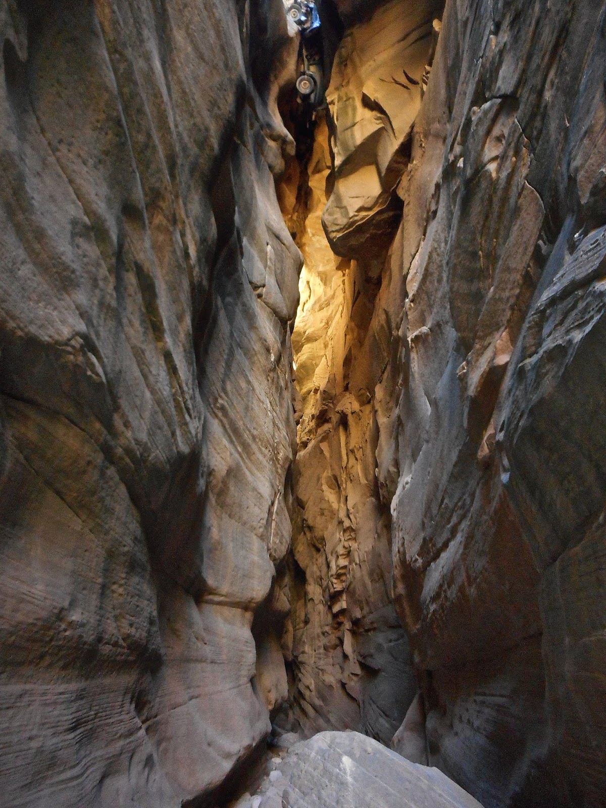
Bull Valley Gorge is a cool slot canyon located just outside of Cannonville near Kodachrome Basin State Park. To reach it, you will take Kodachrome Road south from Cannonville, and turn right onto the Skumptah Road. You will then follow this pretty well-maintained dirt road approximately nine miles to where the road crosses a bridge, just 1.8 miles past Willis Creek. After parking, you will find a well-used trail heading north along the east side of the canyon. After walking a short distance, you can look back at the bottom of the bridge, to see where a jeep famously crashed into the gorge and became wedged. Keep following the trail for a mile or so until the gorge becomes shallow enough to climb into. Once inside, just follow it up as far as you would like. 

There are some minor obstacles that you will need to climb down,  but nothing too tricky. The hardest part for me was climbing back out of the canyon at the initial entry point. I ended up finding a ledge to climb up on the side of the canyon a little past where I had dropped in. There is also the potential for some deep wading. When I visited in November of 2018, I had to wade through some thigh-high ice water to make it to the bridge. I actually broke through the ice covering some of the pools, and sunk at least a foot deep into the mud in one of them. A little after passing under the bridge and seeing the jeep, the canyon began to widen slightly, and I encountered another deep pool. Figuring I had seen the most scenic parts of the canyon already, I decided to turn back. If I were here on a warm day, I would have kept going up the canyon. It's possible to follow Bull Valley Gorge to Sheeps Creek and follow it to Willis Creek, making one long loop hike through two really cool slot canyons. I've heard its possible to see some petroglyphs along this route. 

I had Bull Valley Gorge to myself when I hiked it, though I did hear a couple groups of people talking up around the bridge. Apparently a lot of people just stop at Bull Valley Gorge to look at the jeep wreck from above. This is one canyon that was much more impressive than I was expecting. For some reason, the pictures I had seen of it on-line didn't really impress me so I never had it on my to-do list until recently. But it is definitely worth your time and makes a great add-on to the Willis Creek hike.       

WAHWEEP HOODOOS

APRIL 2008 & NOVEMBER 2011
WAHWEEP HOODOOS

WAHWEEP HOODOOS

WAHWEEP HOODOOS


WAHWEEP HOODOOS


WAHWEEP HOODOOS

WAHWEEP HOODOOS

WAHWEEP HOODOOS

WAHWEEP HOODOO


WAHWEEP HOODOOS

WAHWEEP HOODOOS


The Wahweep Hoodoos are some really interesting geological formations located just outside the town of Big Water, Utah. To reach the trailhead, you will turn north on Ethan Allen Road, which is located directly across the street form the Big Water Grand Staircase-Escalante Visitors Center on Highway 89. After traveling approximately three miles down the road, there will be a parking area just before a large wash. The road is easily-accessible to low-clearance vehicles. If you have a high-clearance vehicle, you can travel down the road a bit further to shorten the hike slightly.  

From the parking area, all you need to do is walk up the wash. All of the hoodoos will be on the left side of the wash with the first group appearing after about three miles, and the last group appearing at about four-and-a-half miles. Walking in the sandy wash can be slow going, so look for a dirt path to the left on your way up along some sections. While on the dirt path, keep an eye out for jack rabbits. The jack rabbits here are huge, and not very afraid of humans (or they just have really poor senses), as they won't run away until you were within just a few feet of them. Bring lots of water as there is none to be found in the area, and the entire hike is through open desert. This could be a brutal hike in the summer, so I would recommend going in the fall, winter or spring. The first time I hiked this in April of 2008, I remember it being extremely windy, and all the sand blowing into my face making the walk a bit unpleasant on the way up. However, the hike was definitely worth it, as the wind eventually died down, and I ended up having the place entirely to myself. I think the long walk through desert to reach the hoodoos makes you appreciate them more. 

I visited again in November of 2011 while in the area, and had a much more pleasant hike. I only remember seeing one or two groups of hikers along the way, and having the hoodoos all to myself again. Due to the remoteness of the area, I doubt this trail ever receives too many hikers. As I had stared the hike late in the afternoon, I remember running a bit towards the end, to be sure I could find my car before it got dark.